Weasel Fire update for the morning of August 12th

Summary: The weasel Fire added 156 acres yesterday, mostly along the western edge and to the northeast and east in Canada…

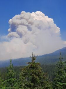
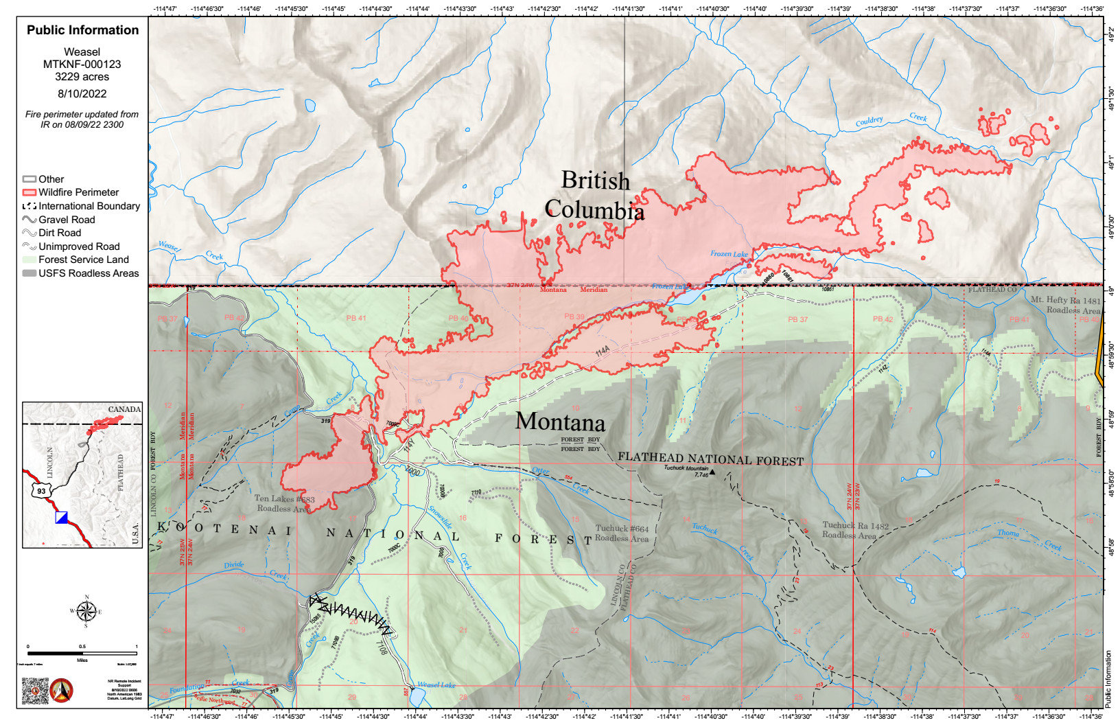
According to this morning’s IR (heat mapping) pass, the Weasel Fire gained 156 acres yesterday and is now estimated at 3401 acres, with a little over half its area in Canada. Expansion was distributed mostly along the western edge in Lincoln County and, in Canada, along the northeast and to the leading edges of the “island perimeters” east of the main burn. The blaze is currently burning in the Kootenai National Forest, the far northwest corner of the North Fork in the Flathead Forest’s Glacier View district, and in Canada. See the attached map for fire location and extent.

The US and Canada are working together to control the Weasel Fire. From the InciWeb site: Jurisdictional collaboration is occurring between the Incident Management Team (IMT) in the United States located in Eureka, Montana and the BC Wildfire Service Incident Management Team in Canada, located in Cranbrook. The two IMT’s are closely coordinating on wildfire management and are sharing resources as required.

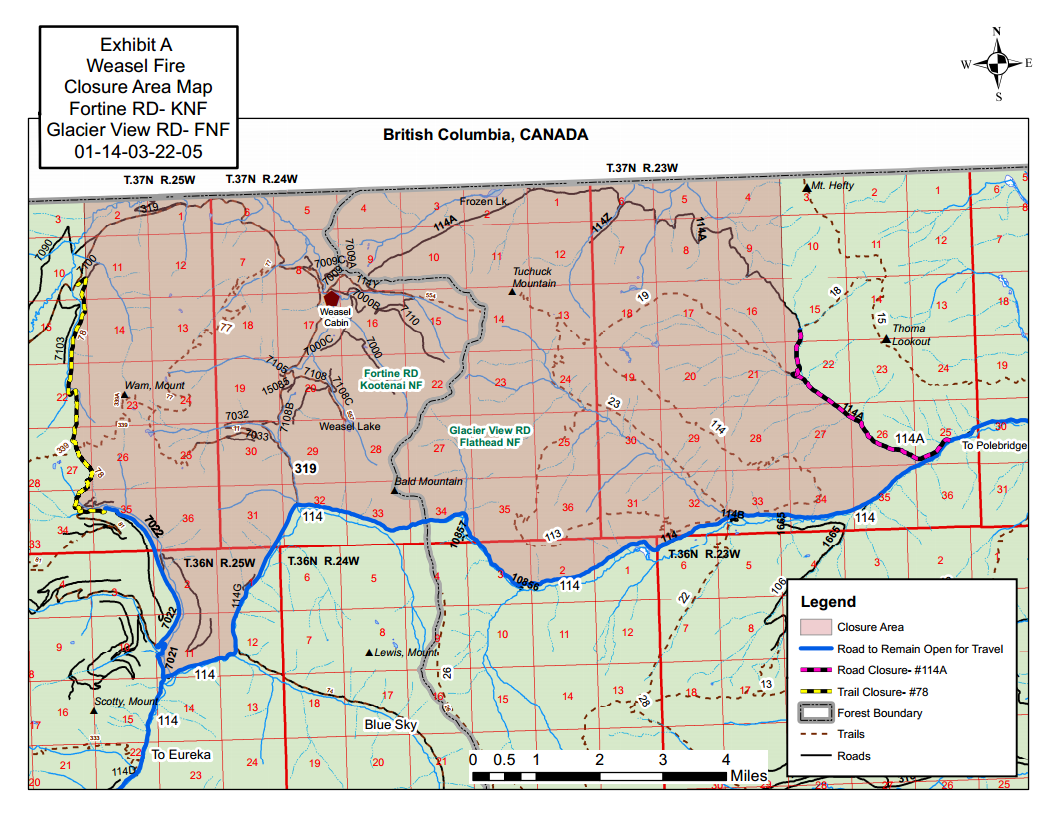
The area closure associated with the fire was finalized August 9 and includes segments of both the Kootenai and Flathead Forests. For the North Fork, this affects an area above Trail Creek Road north to the border and from the Whitefish Divide east to the Frozen Lake Road vicinity. Trail Creek Road remains open. See the attached map and closure order document. Also note that, beginning August 22, major work will be in progress in the Glacier View Ranger District on Trail Creek Road (NFS 114) that will restrict travel for about a month.

Monitor the Weasel Fire InciWeb site for additional information (https://inciweb.nwcg.gov/incident/8290/); in Canada, visit the British Columbia Wildlife Service “Weasel Creek Fire” site (http://bcfireinfo.for.gov.bc.ca/hprScripts/WildfireNews/OneFire.asp?ID=883). Also keep an eye on the NFLA website for fire-related postings.
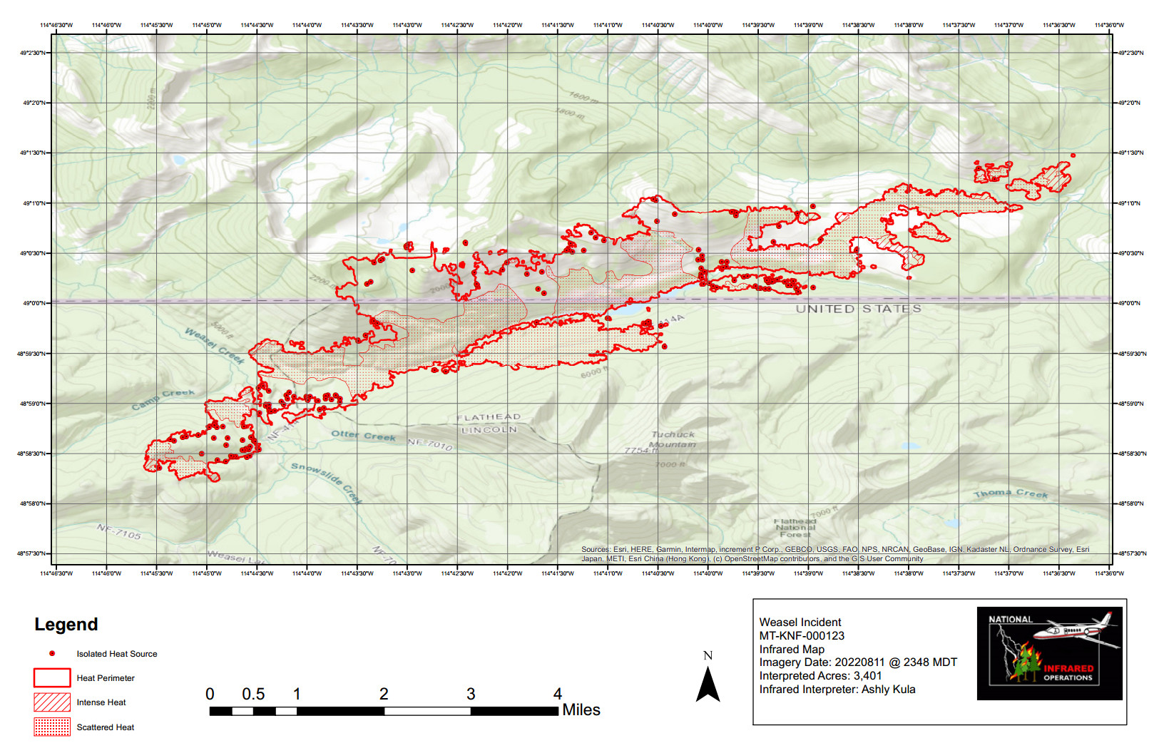
Weasel Fire Heat Map, August 12, 2022
Weasel Fire Area Closure Map

Weasel Fire update for the morning of August 11th

Weasel Creek Wildfire - Aggressive fire behaviour witnessed at 1600 August 8 - BC Wildlife Service (Canada)
Weasel Creek Wildfire – Aggressive fire behaviour witnessed at 1600 August 8 – BC Wildlife Service (Canada)

Summary: The weasel Fire added only 16 acres yesterday, with minor advances in the same areas that have been active the past few days…

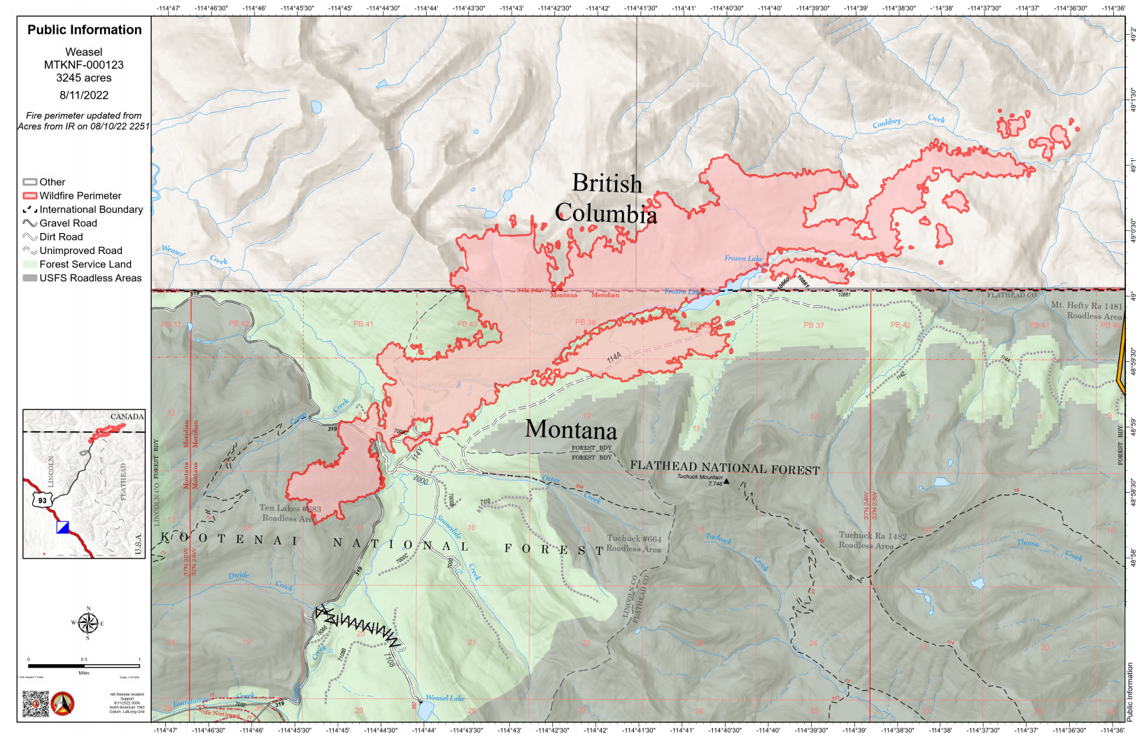
According to this morning’s IR (heat mapping) pass, the Weasel Fire gained 16 acres yesterday and is now estimated at 3245 acres, with a little over half its area in Canada. Expansion was distributed across the areas that have been active over the past few days: the Kootenai National Forest to the west, along the eastern/northeastern perimeter in Canada and in a section of the southern perimeter in the neighborhood of Frozen Lake where it is approaching the old 2017 Weasel burn scar. The blaze is currently burning in the Kootenai National Forest, the far northwest corner of the North Fork in the Flathead Forest’s Glacier View district, and in Canada. See the attached map for fire location and extent.

The US and Canada are working together to control the Weasel Fire. From the InciWeb site: Jurisdictional collaboration is occurring between the Incident Management Team (IMT) in the United States located in Eureka, Montana and the BC Wildfire Service Incident Management Team in Canada, located in Cranbrook. The two IMT’s are closely coordinating on wildfire management and are sharing resources as required.

The area closure associated with the fire was finalized August 9 and includes segments of both the Kootenai and Flathead Forests. For the North Fork, this affects an area above Trail Creek Road north to the border and from the Whitefish Divide east to the Frozen Lake Road vicinity. Trail Creek Road remains open. See the attached map and closure order document. Also note that, beginning August 22, major work will be in progress in the Glacier View Ranger District on Trail Creek Road (NFS 114) that will restrict travel for about a month.

Monitor the Weasel Fire InciWeb site for additional information (https://inciweb.nwcg.gov/incident/8290/); in Canada, visit the British Columbia Wildlife Service “Weasel Creek Fire” site (http://bcfireinfo.for.gov.bc.ca/hprScripts/WildfireNews/OneFire.asp?ID=883). Also keep an eye on the NFLA website for fire-related postings.
Weasel Fire Map, August 11, 2022
Weasel Fire Area Closure Map

Weasel Fire update for the morning of August 10th

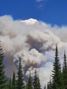
Weasel Fire - Smoke Column, August 4, 2022 - USFS
Weasel Fire – Smoke Column, August 4, 2022 – USFS

Summary: The weasel Fire added 162 acres yesterday, mostly to the west, south and east…

According to this morning’s IR (heat mapping) pass, the Weasel Fire gained 162 acres yesterday and is now estimated at 3229 acres. Most of the expansion was in the Kootenai National Forest to the west, along the eastern perimeter in Canada and in a section of the southern perimeter in the neighborhood of Frozen Lake where it is approaching the old 2017 Weasel burn scar. The blaze is currently burning in the Kootenai National Forest, the far northwest corner of the North Fork in the Flathead Forest’s Glacier View district, and in Canada. See the attached map for fire location and extent.

The US and Canada are working together to control the Weasel Fire. From the InciWeb site: Jurisdictional collaboration is occurring between the Incident Management Team (IMT) in the United States located in Eureka, Montana and the BC Wildfire Service Incident Management Team in Canada, located in Cranbrook. The two IMT’s are closely coordinating on wildfire management and are sharing resources as required.

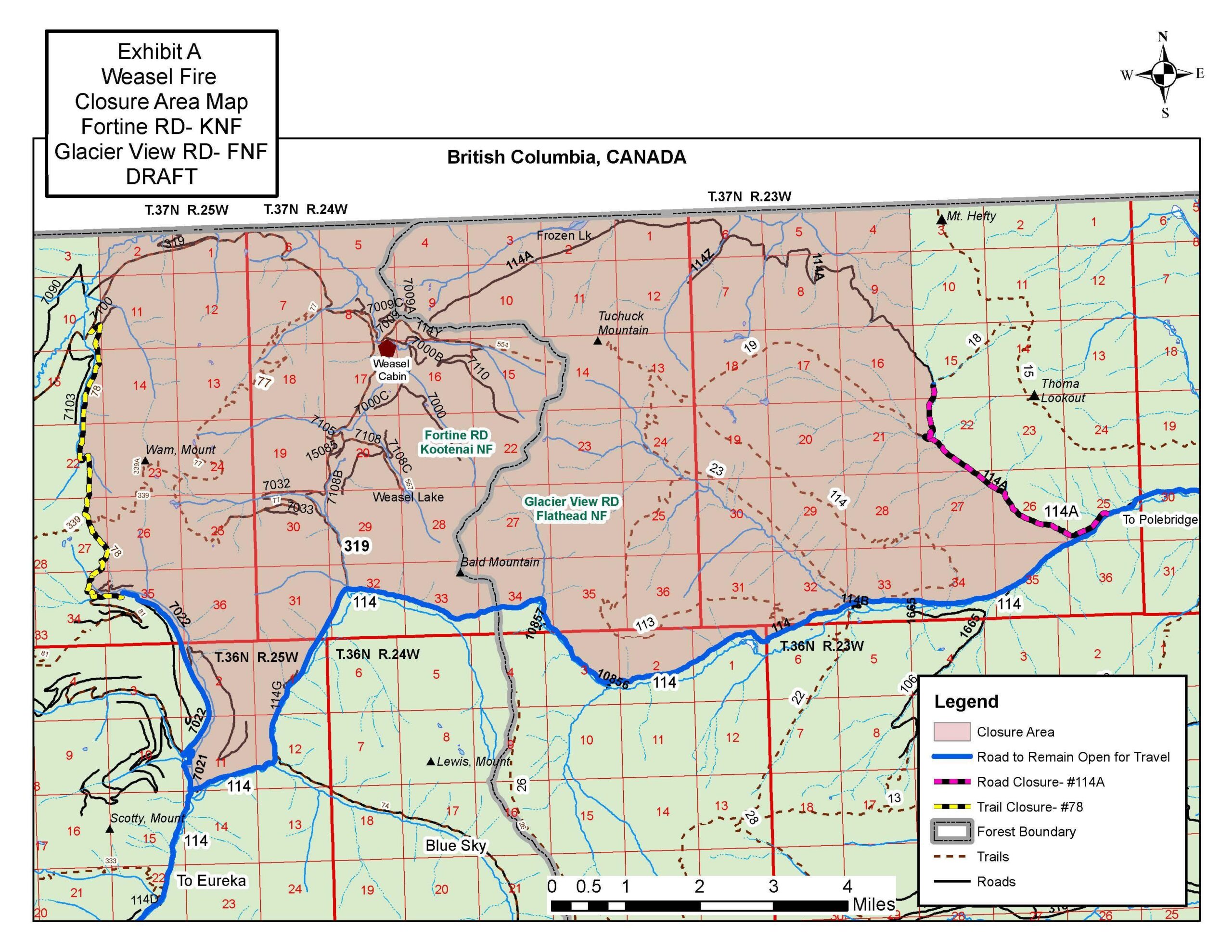
The area closure associated with the fire was finalized August 9 and includes segments of both the Kootenai and Flathead Forests. For the North Fork, this affects an area above Trail Creek Road north to the border and from the Whitefish Divide east to the Frozen Lake Road vicinity. Trail Creek Road remains open. See the attached map and closure order document.

Monitor the Weasel Fire InciWeb site for additional information: https://inciweb.nwcg.gov/incident/8290/. Also keep an eye on the NFLA website for fire-related postings.
Weasel Fire Map, August 10, 2022
Weasel Fire Area Closure Map

Document: Weasel Fire Area Closure Order (PDF format)


Trail Creek Road major maintenance starts August 22nd

Heads up! Trail Creek Road is going to get some serious maintenance starting August 22nd. Note that this will not affect access to private property.

From Rob Davies Hungry Horse/Glacier View District Ranger…

Please pass this on to any individual or organization that might be affected by this road closure.

Continue reading Trail Creek Road major maintenance starts August 22nd

Weasel Fire update for the morning of August 9th

Weasel Cabin Wrapped - Daniel Lemer
Weasel Cabin Wrapped – Daniel Lemer

Summary: As several people in the north end noticed, the Weasel Fire made a substantial run yesterday, increasing by 525 acres…

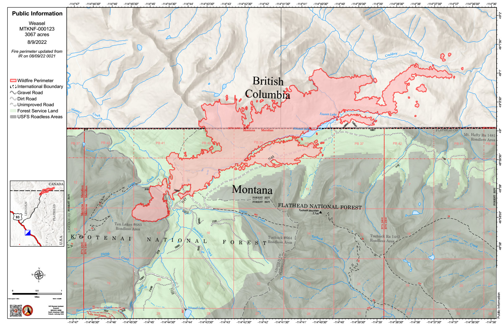
According to this morning’s IR (heat mapping) pass, the Weasel Fire gained 525 acres yesterday and is now estimated at 3067 acres. Most of the advances were along the eastern perimeter in Canada and along a section of the southern perimeter in the neighborhood of Frozen Lake. Within the North Fork, the fire crossed a segment of Frozen Lake Road paralleling the border, but did not move farther east. Again, a little more than half the overall fire acreage is in Canada. The blaze is currently burning in the Kootenai National Forest, the far northwest corner of the North Fork in the Flathead Forest’s Glacier View district, and in Canada. See the attached map for fire location and extent.

The US and Canada are working together to control the Weasel Fire. From the InciWeb site: Jurisdictional collaboration is occurring between the Incident Management Team (IMT) in the United States located in Eureka, Montana and the BC Wildfire Service Incident Management Team in Canada, located in Cranbrook. The two IMT’s are closely coordinating on wildfire management and are sharing resources as required.

The area closure associated with the fire now includes segments of both the Kootenai and Flathead Forests. For the North Fork, this affects an area above Trail Creek Road north to the border and from the Whitefish Divide east to the Frozen Lake Road vicinity. Trail Creek Road remains open. See the attached map for details.

Monitor the Weasel Fire InciWeb site for additional information: https://inciweb.nwcg.gov/incident/8290/. Also keep an eye on the NFLA website for fire-related postings.
Weasel Fire Map, August 9, 2022
Weasel Fire Area Closure Map

Weasel Fire update for the morning of August 8th

Weasel Fire - Smoke Column, August 4, 2022 - USFS
Weasel Fire – Smoke Column, August 4, 2022 – USFS

Short version: The Weasel Fire grew by 230 acres yesterday, most of it in Canada…

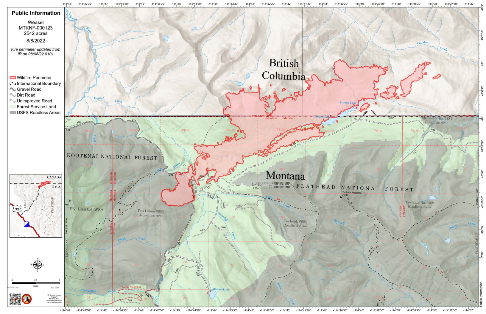
According to this morning’s IR (heat mapping) pass, the Weasel Fire gained 230 acres yesterday and is now estimated at 2542 acres. The western perimeter of the fire grew along Weasel Creek, about 0.2 miles west of the Lincoln/Flathead County line, but the bulk of the increase was along the northeastern and eastern edges of the burn in Canada. A little more than half the fire acreage is now in Canada. The blaze is currently burning in the Kootenai National Forest, the far northwest corner of the North Fork in the Flathead Forest’s Glacier View district, and in Canada. See the attached map for fire location and extent.

The US and Canada are working together to control the Weasel Fire. From the InciWeb site: Jurisdictional collaboration is occurring between the Incident Management Team (IMT) in the United States located in Eureka, Montana and the BC Wildfire Service Incident Management Team in Canada, located in Cranbrook. The two IMT’s are closely coordinating on wildfire management and are sharing resources as required.

The area closure associated with the fire now includes segments of both the Kootenai and Flathead Forests. For the North Fork, this affects an area above Trail Creek Road north to the border and from the Whitefish Divide east to the Frozen Lake Road vicinity. Trail Creek Road remains open. See the attached map for details.

Monitor the Weasel Fire InciWeb site for additional information: https://inciweb.nwcg.gov/incident/8290/. Also keep an eye on the NFLA website for fire-related postings.
Weasel Fire Map, August 8, 2022
Weasel Fire Closure Map, August 6, 2022

Reminder: Land use plan amendment needs your support on August 10th!

[Updated to add links to download the text amendment documents.]

This Wednesday, August 10th is the North Fork Land Use Advisory Committee’s presentation of our revised text amendment to the planning board! Last June, the planning board had issues and our proposal was tabled. Since then a sub-committee has been revising the text amendment in conjunction with the county planning office and a work session with the planning board. This product has been pared down based on recommendations and, although we are confident, we need your support. This support consists of emailing (best option) or writing to the planning office (time sensitive), or showing up at the meeting in person or via zoom. Please encourage your friends and neighbors. Below, I have listed the county email site they prefer, the date, time and location of the meeting, and the planning board zoom link. Please note we are 8th — last on the agenda. If you have any questions or concerns please let me know!

Randy Kenyon
Chair, NFLUAC Continue reading Reminder: Land use plan amendment needs your support on August 10th!

Weasel Fire update for the morning of August 7th

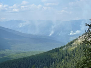
Weasel Fire on August 5, 2022, by Leif Haugen, Thoma Lookout

Using information from various online resources…

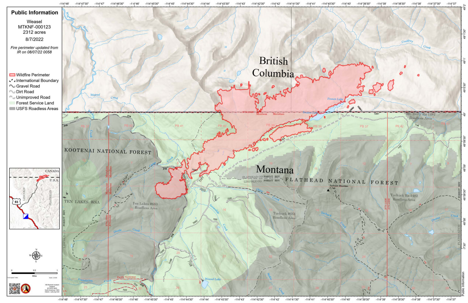
According to this morning’s IR (heat mapping) pass, the Weasel Fire gained another 38 acres yesterday and is now estimated at 2312 acres (the estimate posted last night was 2384 acres). The blaze is currently burning in the Kootenai National Forest, the far northwest corner of the North Fork in the Flathead Forest’s Glacier View district, and in Canada. See the attached map for fire location and extent.

The US and Canada are working together to control the Weasel Fire. From the InciWeb site: Jurisdictional collaboration is occurring between the Incident Management Team (IMT) in the United States located in Eureka, Montana and the BC Wildfire Service Incident Management Team in Canada, located in Cranbrook. The two IMT’s are closely coordinating on wildfire management and are sharing resources as required.

The area closure associated with the fire was increased to include segments of both the Kootenai and Flathead Forests yesterday. For the North Fork, this affects an area above Trail Creek Road north to the border and from the Whitefish Divide east to the Frozen Lake Road vicinity. Trail Creek Road remains open. See the attached map for details.

Monitor the Weasel Fire InciWeb site for additional information: https://inciweb.nwcg.gov/incident/8290/. Also keep an eye on the NFLA website for fire-related postings.
Weasel Fire Map, August 7, 2022
Weasel Fire Closure Map, August 6, 2022

Weasel Fire update for the morning of August 6th

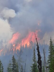
Weasel Fire - Extreme Fire Behavior, August 4, 2022 - USFS
Weasel Fire – Extreme Fire Behavior, August 4, 2022 – USFS

Using information from various online resources…

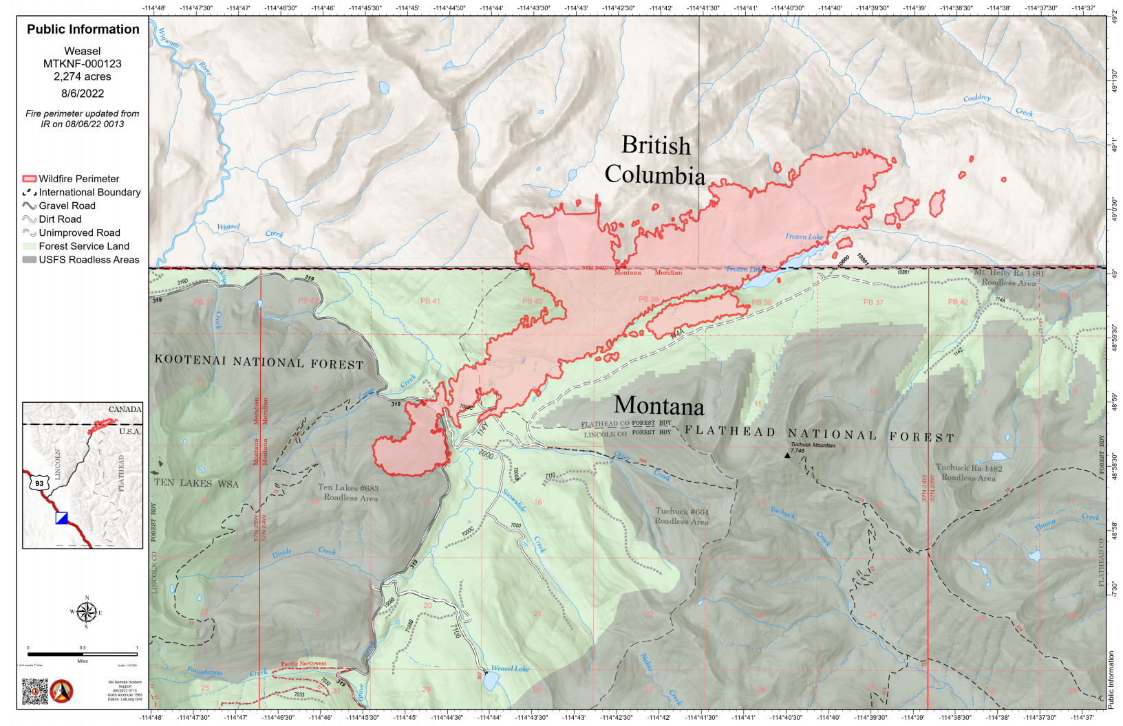
The Weasel Fire gained another 100 acres yesterday and is now estimated at 2274 acres. The blaze is currently burning in the Kootenai National Forest, the far northwest corner of the North Fork in the Flathead Forest’s Glacier View district, and in Canada. The Weasel fire has done a fair bit of spotting beyond the main perimeter and is still quite active. See the accompanying map for information on the fire’s extent.

There’s no official word yet on North Fork area trail and road closures, although it is safe to assume that at least some of the trails and Forest Service roads north of Trail Creek Road will be off-limits. There are no current plans to close Trail Creek Road itself.

Monitor the Weasel Fire InciWeb site for additional information: https://inciweb.nwcg.gov/incident/8290/. Also keep an eye on the NFLA website for fire-related postings.
Weasel Fire Map, August 6, 2022

Glacier Park bridge restoration project update

From the official press release. This mostly discusses the bridge work on the “Inside” North Fork Road, but also note the reference to work on the “North Fork Bridge,” which apparently means the Camas Bridge to us normal people…

WEST GLACIER, Mont. [August 5, 2022] – In a July press release Glacier National Park announced a construction project to rehabilitate 13 bridges throughout the park. Since then, work has begun on the Anaconda, Camas, and Dutch Creek Bridges located on the Inside North Fork Road.

Continue reading Glacier Park bridge restoration project update